31348: DUN STUIGH, GREAT BERNERA – BROCH? (Undated)
Summary:
BROCH? (Undated)
Probable broch, or dun, on promontory
Location:
NB 1540 4025
Full description:
NB14SE 2 1540 4025.
(NB 1540 4025) Dun Stuigh (NR)
OS 6"map, (1965)
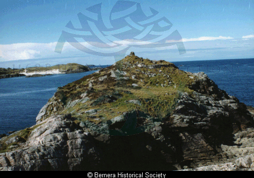
The remains of Dun Stuigh, a probable broch, lie on the outer extremity of a narrow, rocky promontory, isolated by a deep cleft which makes access difficult.
It has measured 45′ in external diameter with walls varying from 9′ to 10′ in thickness. The outer face of the wall is traceable all round except on the NE, and the best preserved part, to the SE shows only 3′ in height of building in position; the interior is filled with tumbled stones. The doorway has possibly been in the NE arc towards the loch, there being slight indications of built jambs 3’3" apart at this place. A gallery in the body of the wall can be seen at different places; at the SE a short length of the outer part of the wall, 2’10" thick remains in position, and on the northern arc, a part of the inner portion of the wall shows a thickness of 4′, but the stones are here slightly displaced, and the original thickness must have been rather less.
RCAHMS 1928, visited 1914.
Dun Stuigh, as described by the RCAHM, except that it measures 14.2m N-S by 13.2m E-W. Part of the outer face on the E and W sides has been eroded by the sea. Though the walls are well built and appear to follow a regular curve, it is more likely to be a galleried dun, due to its small size, shape and thickness of walls (c. 3.0m), and the fact that the E entrance lies on its shorter axis. Name still known locally.
Re-surveyed at 1/10,560.
Visited by OS (N K B) 22 June 1969.
‘The monument…comprises of the remains of a galleried dun, a fortified settlement of late Iron Age date (300BC-300AD). The area to be scheduled is circular, with a maximum diameter of 25m centred on the dun.’
HS Scheduling Document 27 January 1992.
References:
RCAHMCS. 1928. The Royal Commission on the Ancient and Historical Monuments and Constructions of Scotland. Ninth report with inventory of monuments and constructions in the Outer Hebrides, Skye and the Small Isles, Publisher: HMSO The RCAHMS 9th Report and Inventory: Outer Hebrides, Skye and the Small Isles. 20, No. 70
Acknowledgement:
Information provided by Western Isles Council Sites & Monuments Record, January 2006.
Record Location
Details
- Record Type:
- Historical or Archaeological Site
- Type Of Site:
- Broch
- SMRRecord ID:
- MWE4122
- Record Maintained by:
- CEBL
Related Media
Dun Stuigh