32194: ST. COLUMB’S CHURCH, EILEAN CHALUIM CHILLE, LEWIS
Summary:
CHURCH (Medieval – 1266 AD to 1539 AD)
GRAVE (Medieval – 1266 AD to 1539 AD)
Church on early monastic site
NB 3858 2104
Full description:
NB32SE 3858 2104.
(NB 383 210) St Columb’s Church (NR) (In Ruins)
OS 6"map, Ross-shire, 2nd ed., (1899)
Church of "St Columkil, in the island of that name" – listed.
M Martin 1934.
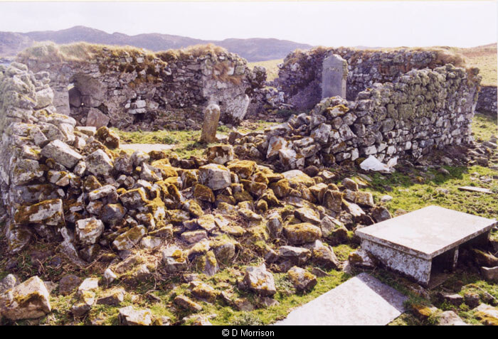
The church stands in a graveyard and is oblong on plan, 29ft 6ins x 13ft 3ins, within walls 2ft 6ins thick and on average 6ft high.
RCAHMS 1928.
St Columb’s Church, as described by the RCAHMS, is situated in a disused graveyard at NB 3858 2104. The entrance in the south wall, together with a round-headed splayed window, was blocked when the church was used as a private burial vault.
Visited by OS (N K B) 23 June 1969.
‘The monument…comprises the remains of a single chambered early mediaeval church within a burial ground. The area to be scheduled is irregular and measures a maximum of 30m N-S by 30m E-W to include the Church and burial ground.’
HS Scheduling Document 17 Februaury 1992.
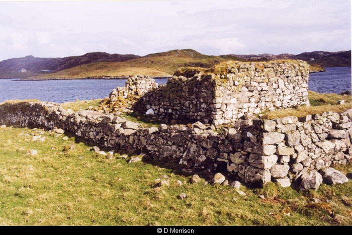
"Situated on the southern shores of Eilean Chalium Cille, approximately 300 metres to the south-west of the modern causeway, this building measures 10 metres from west to east, 6 metres from north to south and stands to a maximum height of 2 metres. Its walls are up to 1 metre thick constructed of rough stone boulders bonded with a coarse mortar. Large areas of collapse can be seen at the west end of the south wall and the south end of the east wall making the identification of an entrance difficult. A window may be seen at the east end of the south wall. This window is formed as a crude ‘Saxon’ (one centred) arch, and the opening tapers from 0.75 metres on the building’s interior to 0.5 metres on its exterior. Standing 1.25 metres tall the form of this opening, though crude in construction, is similar to those seen in other Teampulls around the shores of Lewis, most notably that at Eorpie – St Mholuidh. The remains of a second opening can be seen in the collapsed area at the west end of the southern wall. The true form of the opening is unclear due to the tumbled nature of the wall at this point, however, its location and size, 1 metre in width, suggests that it is likely to be the remains of a door or entrance. Internally, three recent (19th century) gravestones can be identified standing towards the west end of this structure. The presence of these stones has contributed to the argument in recent years of the date and origin of the building. The site, or at least the island, on which it stands is traditionally held to be the site of the first arrival of Christian, Columban, monks in the northern Western Isles. What seems certain is that the current structure isn’t the one that the early Christian settlers would have built. That structure is likely to have been similar in form to the early church identified on Iona, being constructed of wood, or if timber was scarce perhaps of turf. The debate over the current – upstanding – structure seems to be whether it is medieval or late post-medieval (17th century) in origin, and therefore whether it is the remains of a medieval (Roman Catholic) Teampull similar to those seen primarily on Lewis’s west coast, or whether it was constructed primarily as a mausoleum during the 17th or 18th centuries. The examination possible during the current survey suggests that the structure has its origins at least in the medieval period. In form, size and construction it is very similar to many of the Teampull sites on the west coast of the island, not least Tigh na Bheannaich at Gallen Head (Aird Uig) which is thought to be a relatively early church. Furthermore, those architectural details visible – particularly the window at the east end of the southern wall – suggest parallels in style with churches such as those at Eorpie and Galson, both of which have been firmly dated to the medieval period. The enclosure surrounding this building (15.4) also includes a number of apparently early grave slabs on its east side, between the chapel’s east wall and the enclosure’s (15.4) east wall. These ‘rude’ markers are typical of those associated elsewhere in Scotland and wider Europe with the burial of early Christian monks. However, on Lewis the use of such crude grave markers can be seen right through to the late 19th century, so the date of these features remains in question." (Burgess 2004, 86-88)
References:
Martin Martin. 1695. A description of the Western Islands of Scotland circa 1695, Editor: Macleod, D J (ed,), Publisher: Eneas Mackay, A Description of the Western Islands of Scotland c. 1695. 27 (2nd ed. 1716)
RCAHMCS. 1928. The Royal Commission on the Ancient and Historical Monuments and Constructions of Scotland. Ninth report with inventory of monuments and constructions in the Outer Hebrides, Skye and the Small Isles, Publisher: HMSO The RCAHMS 9th Report and Inventory: Outer Hebrides, Skye and the Small Isles. 11, No. 37
Chris Burgess, Northamptonshire Archaeology. 2004. Northamptonshire Archaeology Archaeological Survey and Evaluation of Eilean Chalium Chille and the Putative Site of the Seaforth Head Castle. Part No Loch Seaforth Head Gazeteer.
Acknowledgement:
Information provided by Western Isles Council Sites & Monuments Record, January 2006.
Record Location
Details
- Record Type:
- Historical or Archaeological Site
- Type Of Site:
- Church; Grave
- Period:
- Medieval (1266-1539 AD)
- SMRRecord ID:
- MWE4233
- Record Maintained by:
- CEP
Related Media
St Colm’s Old Church, Eilean Chaluim Chille
St Colms, outbuildings