33084: LIONGOL, KNEEP, LEWIS
Summary:
FARMSTEAD (Post Medieval – 1540 AD to 1900 AD)
ENCLOSURE (Post Medieval – 1540 AD to 1900 AD)
19th C. farmstead
Location:
NB 0975 3625
Full description:
NB03NE 51.03 0975 3625
(Formerly NB03NE 40)
Two roofed buildings and one unroofed building are depicted on the 1st edition of the OS 6-inch map (Island of Lewis, Ross-shire 1853, sheet 12). One unroofed and one enclosure are shown on the current edition of the OS 1:10000 map (1974).
Information from RCAHMS (AKK) 18 September 1997.
no. 54
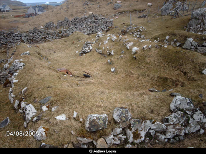
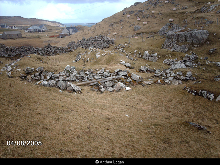
The deserted blackhouse settlement of Liongol is located between two rocky ridges, with views over both Traigh Cnip and Tragh na Berie. The site comprises the remains of a substantial blackhouse, a large enclosure and two fragmentary enclosures. Numerous otehr boundary walls relating to the settlement are represented on the 1st edition Ordnance Survey map.
The focus of the settlement comprises two adjoining blackhouses, sharing a long wall and aligned north-north-west/south-south-east. Both have stone outer and inner faces with a turf/earth core. The walls average c. 1.5m high externally and c. 1m high internally. Both have a single internal partition, and neither has any internal variation in vegetation cover. The partition of the northern structure contains some exceptionally large sontes. The walls are c. 1-1.5m in width, relatively well-preserved and regular in construction with no markedly rounded internal corners.
The northern most of the two is 15m by 3m internally and has an entrance in the western end of its northern long wall. Opposite this is the entrance into the other structure which has internal dimensions of c. 15 by 2.5m. The southern structure is entered only through the northern showing that the two were in use contemporaneously, although either may have been constructed earlier on the basisi of the survey information. The northern structure is in generally poorer repair but this is not necessarily any guide to its chronological primacy. Ther northern structure has had its eastern end re-faced, while, in the northern structure this end contains a box-bed.
The largest of the associated enclosures lies to the west of the blakchouse and survives to 2m in height. It is square and bisected by a north-south wall with gaps at its north and south ends.
A further three-sided enclosure lies to the north-west of the large enclosrue. Its nrothern edge is provided by a rocky ridge. A similar structure also lies to the north-east of the blackhouse. Both structures are formed of collapsed drystone rubble.
The settlement is indicated as occupied on the 1st edition coverage, but appears to be unoccupied on the 2nd edition. It is therefore likely that the settlement was abandoned between the 1850s and 1890s. The 2nd edition map indicates the surviving two adjoining blackhouse structures and the large enclosure, as ewell as the msaller enclosure to the south-east. The absence of gables, fireplaces or mortared walls is instructive in the context of the probable abandonment date of the site.
Armit 1992, 67
References:
Ian Armit. 1992. CFA, University of Edinburgh Archaeological Field Survey of the Bhaltos (Valtos) Peninsula, Lewis.
1994. ‘Archaeological field survey of the Bhaltos (Valtos) peninsula, Lewis’, Proc Soc Antiq Scot. Part No 124. No.54, 88
Acknowledgement:
Information provided by Western Isles Council Sites & Monuments Record, January 2006.
Record Location
Details
- Record Type:
- Historical or Archaeological Site
- Type Of Site:
- Farmstead; Enclosure
- Period:
- Crofting (1850-1950 AD); Post-Medieval (1540-1900 AD)
- SMRRecord ID:
- MWE72745
- Record Maintained by:
- CEU
Related Media
Blackhouse, Liongol
Liongol